Local History
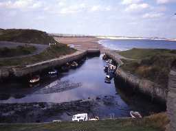
Seaton Sluice (Northumberland)
Seaton Sluice lies on the south-east Northumberland coast, on the border with North Tyneside. Most of the remains are connected with the industrial periods in post-medieval and modern times. Earlier remains mostly lie north of the Seaton Burn in Seaton Delaval.
The major landowners in the area from the medieval period were the Delavals. An early industrial venture were salt pans but the main enterprises of the area were based on the coal and glass industries. Seaton Sluice Harbour was built by Sir Ralph Delaval in the 17th century and became the focus for glassworks, brewery, brickworks, lime kiln and quarry all focused around the harbour. The Hartley Bottle Works was a major post-medieval concern brought to the area by the apparently unlimited supply of sand and coal. The harbour declined by 1820 and in 1862 fell into decay because of the collapse of the local coal trade. Other industries included an ironworks and colliery Mill Pit with its own waggonway.
Defence of this industrialised coast has always been a priority. The Delaval Battery is the earliest of these works, built in the 17th century by Sir Ralph Delaval. In World War I (1914-18) Robert's Battery was built, an unusual coastal turret battery that allowed the defence of both the Blyth and Tyne river mouths at far greater ranges. The same site was reused World War II (1939-45) as a Chain Home Low radar site for defence against air attack, with anti-glider ditches being dug at Holywell and surrounding area. Smaller defences included a series of pillboxes along the coast, such as Sandy Island.
N13844
UNCERTAIN
Disclaimer -
Please note that this information has been compiled from a number of different sources. Durham County Council and Northumberland County Council can accept no responsibility for any inaccuracy contained therein. If you wish to use/copy any of the images, please ensure that you read the Copyright information provided.
